


CARTO & Snowflake: Location Intelligence for Energy and Utilities
CARTO and Snowflake expanding cloud-native Location Intelligence for Energy and Utility organizations, unifying IoT data for resilient operations.


California Wildfire Maps: How fires and smoke are spreading
These maps of the California wildfire crisis put everything in perspective and show just how daunting it is for emergency responders.
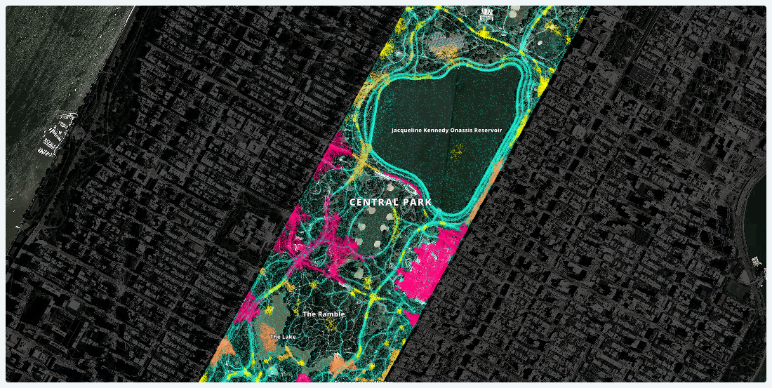
Lessons Learned from Analyzing Over a Million Points of GPS Data
Working with one month of nation-wide GPS data, A Million Walks in the Park explores the use of public spaces, specifically public parks across New York City, to understand social interactions among New Yorkers.


Using Mapbox Vector Tiles in CARTO for Maps & Location Apps
Using Mapbox Vector Tiles in CARTO for Maps & Location Apps

This map shows the communities most vulnerable to Hurricane Irma
We created this map in hopes that public officials and relief organizations can identify the most at-risk neighborhoods and deliver them life-saving resources before and after this disaster strikes.

Introducing CARTOframes: A Python Interface for CARTO
CARTOframes allows data scientists to extract the power of CARTO without leaving their Python environment.

Map of the Month: Pi Project - Connecting the World Through Art
Map of the Month: Pi Project - Connecting the World Through Art

The Future of Location Intelligence
Learn about the latest Location Intelligence trends discussed at CARTO Locations

Our Game of Thrones Basemap is here to unite the Seven Kingdoms
We built a custom basemap of the Game of Thrones world and we’re giving it away for free, with hopes that what you create will help someone unite the seven kingdoms.

A Really Good Guide on Location Intelligence Implementation
Follow this step-by-step Location Intelligence guide to turn your location data into business outcomes.

What Online Retailers Can Learn by Mapping Sales Data
One online retailer based out of New York City was able to measure ROI of their ad campaigns by mapping sales and ad location data.

Opportunity Zones in the Wake of Amazon HQ2
Real estate is still abuzz about the U.S. Treasury Department's creation of 8,700 Opportunity Zones, and in this post learn why Location Intelligence can provide the contextual insights needed for finding the right investments.

Happy PostGIS day!
Happy PostGIS day! Connect CARTO to Franchise, a SQL tool with a notebook interface. Analyze and visualize your PostGIS data seamlessly.

Academy

3 ways Location Intelligence is changing outdoor advertising
See how leading OOH companies use cloud-native spatial analytics and AI to move beyond impression counts and prove campaign ROI.
CARTO & Snowflake: Location Intelligence for Energy and Utilities
CARTO and Snowflake expanding cloud-native Location Intelligence for Energy and Utility organizations, unifying IoT data for resilient operations.

How to get your colleagues and clients excited about geospatial
A practical guide to building internal buy-in for geospatial, with tips on making the case to non-technical colleagues and leaders, speaking the right language.

