Use cases


Retail Site Selection: Complimentary Post Pandemic Playbook
Download our new report on site selection strategies & how location data & advanced spatial analysis can help retailers adapt & thrive in a post pandemic world


Interactive School District Maps & Analysis with WXY
Read how WXY, an architecture, urban design, & planning firm, built an interactive school district dashboard for Montgomery county using the CARTO platform

Agricultural Sustainability with CARTO, Indigo Ag, & Snowflake
With our platform & Snowflake connector, read how Indigo Ag rapidly gathers, styles, & shares insights from spatial models improving agricultural sustainability


How Google Cloud & CARTO power geospatial analysis at scale
Discover how to scale your analytical workflow & access massive geospatial datasets with Google Cloud & CARTO & the general availability of BigQuery Tiler

COVID Vaccine: Mapping Rollout & Optimizing Supply Chain
As COVID vaccines become more widely available we look maps analyzing the rollout & supply chain optimization for an efficient & equitable immunization strategy


Agritech & Spatial Data: Predicting Crop Yield in Agriculture
Read how our partner NGIS built a spatial web application, CroppingHub, to detect crop types & predict crop yield using cloud computing & machine learning

How to Improve Retail Trade Area Accuracy with Mobility Data
Read how to improve retail trade area accuracy by moving beyond buffers & drive times to using spatial analysis & human mobility data
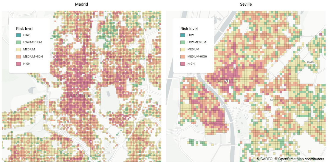


Identifying Areas Most Likely to Suffer Recession Post Pandemic
As many parts of the world enter into recession following the Coronavirus pandemic, read how Spatial Data Science can help identify areas with a greater risk

Human Mobility & Transport Analysis in the Canary Islands
Optimizing transport infrastructure spatially is key to the future of mobility - see how CARTO, Vodafone, & SAGULPA built a platform for the city of Las Palmas
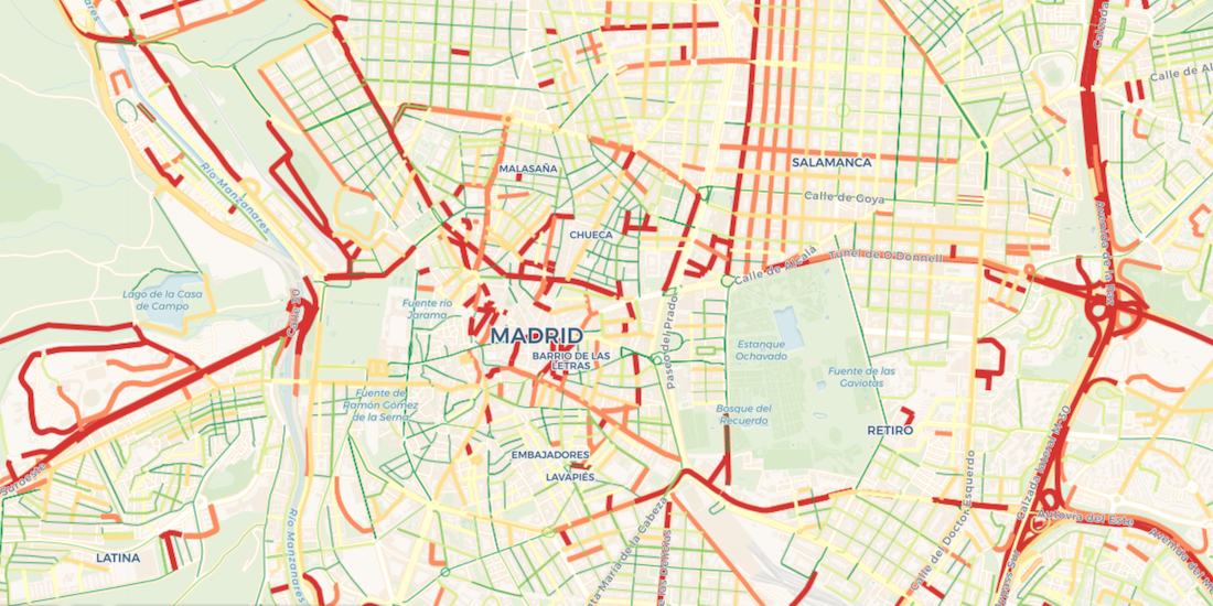
Visualize Waze Traffic Data using Google BigQuery & CARTO
Learn how to import Waze for Cities traffic big data into CARTO using our Google BigQuery Connector for easy analysis & visualization in our step by step guide

Analyzing UK Covid Recovery & Mobility with Avison Young
Explore Avison Young's UK Cities Recovery Index, monitoring commercial real estate rebound post-pandemic, analyzing diverse sectors, and predicting recovery trajectories.

COVID-19 Vaccine: Optimizing Cold Chain Transportation
With COVID-19 vaccines requiring strict storage, ensuring an efficient cold chain transportation network using spatial will be key for effective distribution

Academy

Google Cloud Next 2025: Key takeaways for geospatial
Discover key geospatial insights from Google Cloud Next 2025 - AI, low-code tools, Earth Engine, and more innovations shaping the future of location tech.
.jpg)
Telco dashboards: Turning accessible data into actionable insights
Discover how CARTO enhances data accessibility, empowering decision-makers with actionable insights to improve network access for senior citizens and communities.
The first 5 maps everyone needs to make with CARTO
New to CARTO? Start with these 5 essential maps! Learn how to analyze proximity, work with big data, integrate real-time updates, and leverage AI-driven insights.