

Spatial Analytics


Spatial Analytics in 2026: What's Changing?
Explore how AI, cloud-native tools, and evolving skills are reshaping spatial analytics in 2026, based on insights from 200+ geospatial experts.
.png)
5 best spatial analytics and visualizations of 2025
Discover the best spatial analytics of 2025. Learn how industry leaders use CARTO to analyze historical risk, manage real-time operations, and plan for growth.
.png)

The Changing Role of the GIS Analyst
Discover how GIS Analysts are evolving from map makers to strategic AI-driven experts shaping enterprise decision-making with cloud-native tools.
.png)
Unlock planetary-scale insights with CARTO & Google Earth AI
Learn how CARTO & Google Earth AI make planetary-scale insights accessible with foundation models & Agentic GIS.
%20(1).png)
How to build a geospatial AI roadmap (that actually works)
Only 1 in 4 AI projects deliver ROI. Discover a proven 5-step roadmap for scaling geospatial AI - govern data, automate workflows, and unlock Agentic GIS value.
.png)


Introducing CARTO Site Selection AI Agent for Gemini Enterprise
Transform Site Selection with CARTO’s AI Agent in Google's Gemini Enterprise - analyze, compare, and plan new locations in minutes.
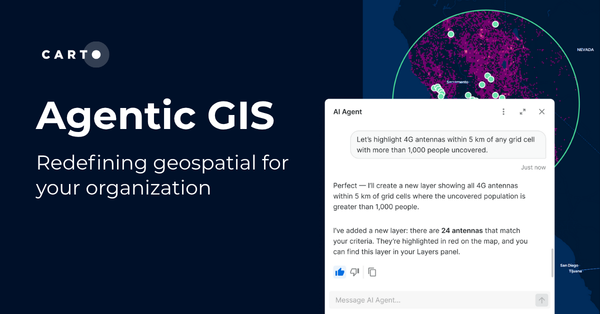

Agentic GIS has landed: redefining geospatial for your organization
Discover how CARTO’s Agentic GIS platform and AI Agents are transforming spatial analysis - making Location Intelligence accessible to everyone.
.png)

CARTO's Territory Planning tools for better location decisions
Optimize your strategy with CARTO's Territory Planning Extension! Enable smarter location decisions, balancing territories & improving logistics for efficiency and growth.
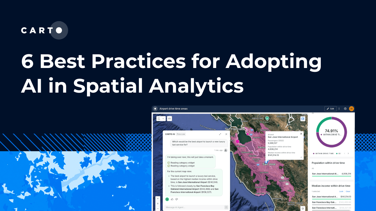
6 best practices for adopting AI in Spatial Analytics
Learn 6 best practices for integrating AI into spatial analytics. Establish a secure, scalable AI strategy to automate tasks and make confident decisions.
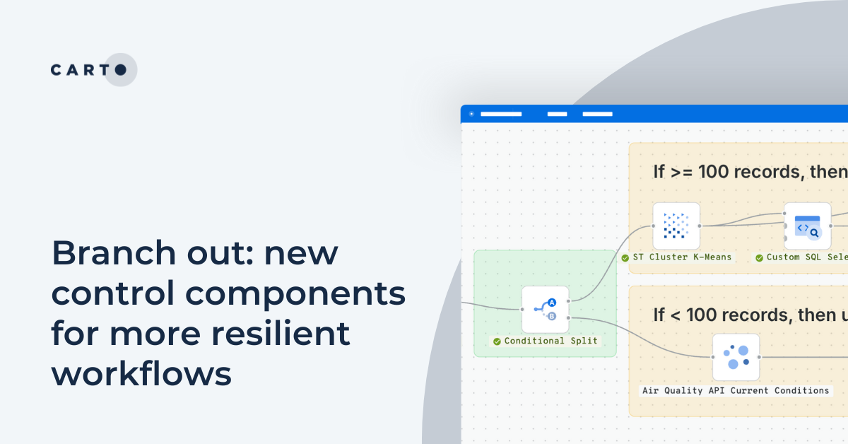
Branch out: new control components for more resilient workflows
Discover CARTO Workflows’ new Conditional & Success/Error Split components to build flexible, resilient spatial analysis pipelines.
.png)

Live maps with automated Workflows integrations are here
Create live, always-updated maps with CARTO by integrating Workflows and Builder. Automate geospatial analysis to visualization in one step.
.png)

Introducing User Comments: boost collaboration in your maps
Boost team collaboration with User Comments in CARTO Builder—add, track, and resolve feedback directly on your enterprise maps.

Academy

CARTO & Snowflake: Location Intelligence for Energy and Utilities
CARTO and Snowflake expanding cloud-native Location Intelligence for Energy and Utility organizations, unifying IoT data for resilient operations.
Nagarro & CARTO: Advancing Enterprise AI Transformation
CARTO and Nagarro partner to help enterprises move AI from pilots to production, embedding Location Intelligence into existing workflows and systems.


Unlock trade-area analysis at scale with H3 Isochrones
Scale travel-time analysis with H3-based isochrones in CARTO. Faster joins, overlap insights, and 96–99% time savings powered by TravelTime.