CARTO MCP Server: turn your AI Agents into geospatial experts


.png)
As every enterprise races to embed AI across their organizations, one question keeps coming up: how do we connect powerful AI agents with the specialized tools, data, and workflows designed for our specific business problems?
For geospatial teams, this also represents an incredible opportunity: expose Location Intelligence capabilities built on years of expertise to every AI agent and decision-maker across your organization, not just GIS specialists.
Today, we're excited to introduce the CARTO MCP Server, a solution that bridges this gap by making your geospatial workflows available to any AI agent across your organization.
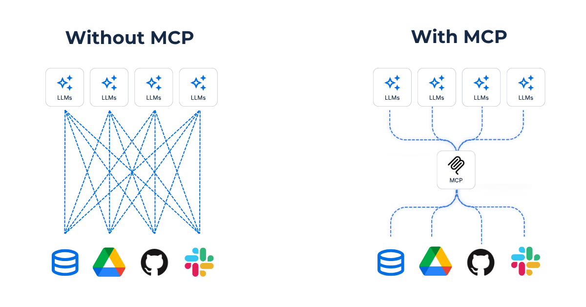
The Model Context Protocol (MCP) is an open standard developed by Anthropic that defines how AI agents communicate with external tools and data sources. Think of it as a universal language that allows any MCP-compliant agent like Gemini, ChatGPT or Claude, to discover and use tools in a standardized way, eliminating the need to customize integrations for every new platform.
Here’s a simpler analogy: MCP is to AI what USB is to a computer. A standardized way of connecting tools and data, but for AI.
The AI ecosystem is evolving rapidly, and organizations can't afford to build and maintain so many integrations. The Model Context Protocol (MCP) solves this by establishing a common connectivity layer: expose your workflows once through MCP and make them instantly available for all AI agents and AI platforms.
For the geospatial industry this is an exciting foundational moment where instead of custom GIS integrations, teams can distribute their workflows everywhere, instantly via a standard like MCP, democratizing access to geospatial insights.
AI agents using MCP gain three critical capabilities for spatial analysis:
- Tools: Agents can execute complex geospatial operations, like routing optimization or site selection analysis, by calling workflows you've built in CARTO.
- Context: Each tool comes with rich semantic information that helps agents understand what a tool does, when to use it, and what parameters it needs.
- Reasoning abilities: Agents can compose sophisticated analyses by chaining multiple tools together, adapting and reasoning with the results.
For example, an AI agent helping with network expansion planning can now use tools to combine your mobility insights workflow with demographic enrichment and competitive analysis—all through natural language, without requiring GIS expertise.
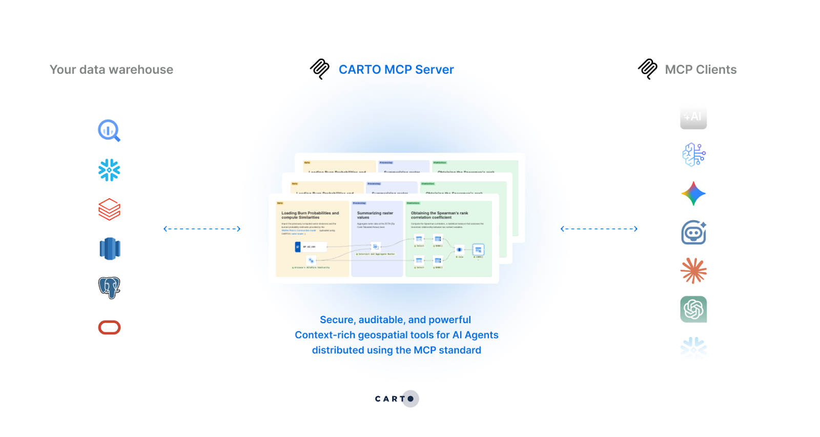
The new CARTO MCP Server is a secure, remote MCP server that enables enterprises to expose their geospatial workflows as MCP tools, making them accessible to any compliant AI agent or platform. Here’s what makes it powerful:
When an AI agent calls an MCP tool backed by a CARTO Workflow, all processing happens directly in your governed cloud environment—whether that's BigQuery, Snowflake, Redshift, or Databricks. Zero data replication, no data movement, and your existing governance policies, access controls, and audit trails remain fully intact.
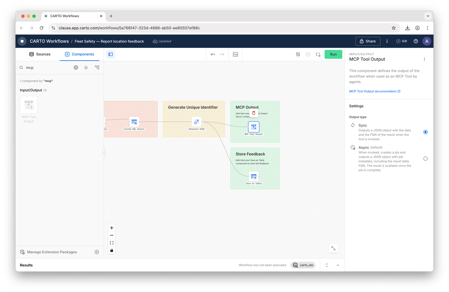
Each MCP tool is powered by a workflow in CARTO—a visual pipeline that defines exactly how the spatial analysis is performed. Instead of unreadable complex queries, this brings transparency, maintainability, collaboration, and version control to the tools that you’re exposing via MCP.
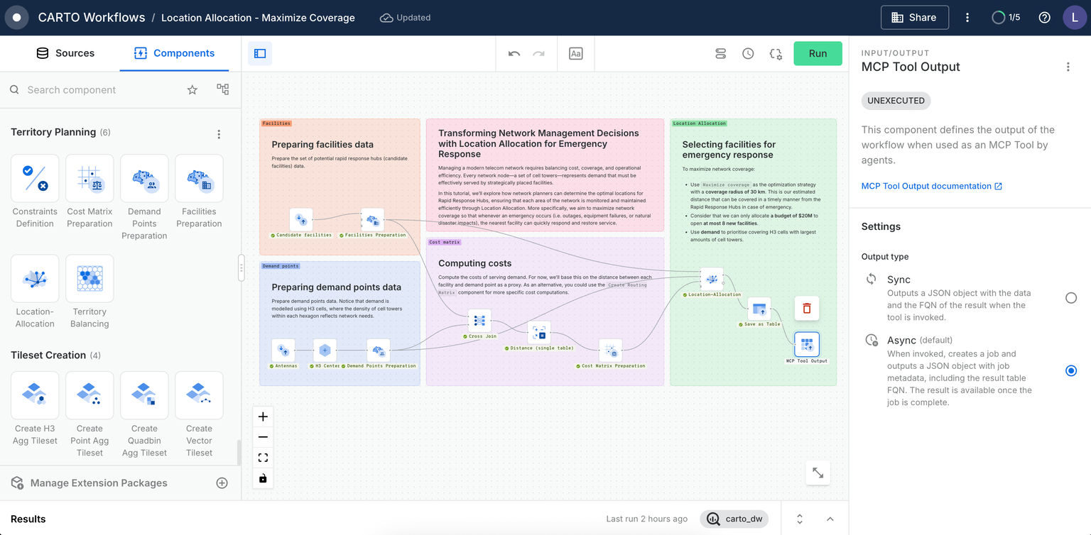
With over 200 components and extensions, CARTO Workflows brings spatial power to AI Agents.
Your agents get instant access to everything from basic spatial operations (buffers, joins, geocoding, routing…) to advanced predictive analytics powered by machine learning and Geospatial Foundation Models. Workflows also integrates with Google Earth Engine and supports custom extensions, turning your agents into spatial analysis powerhouses.
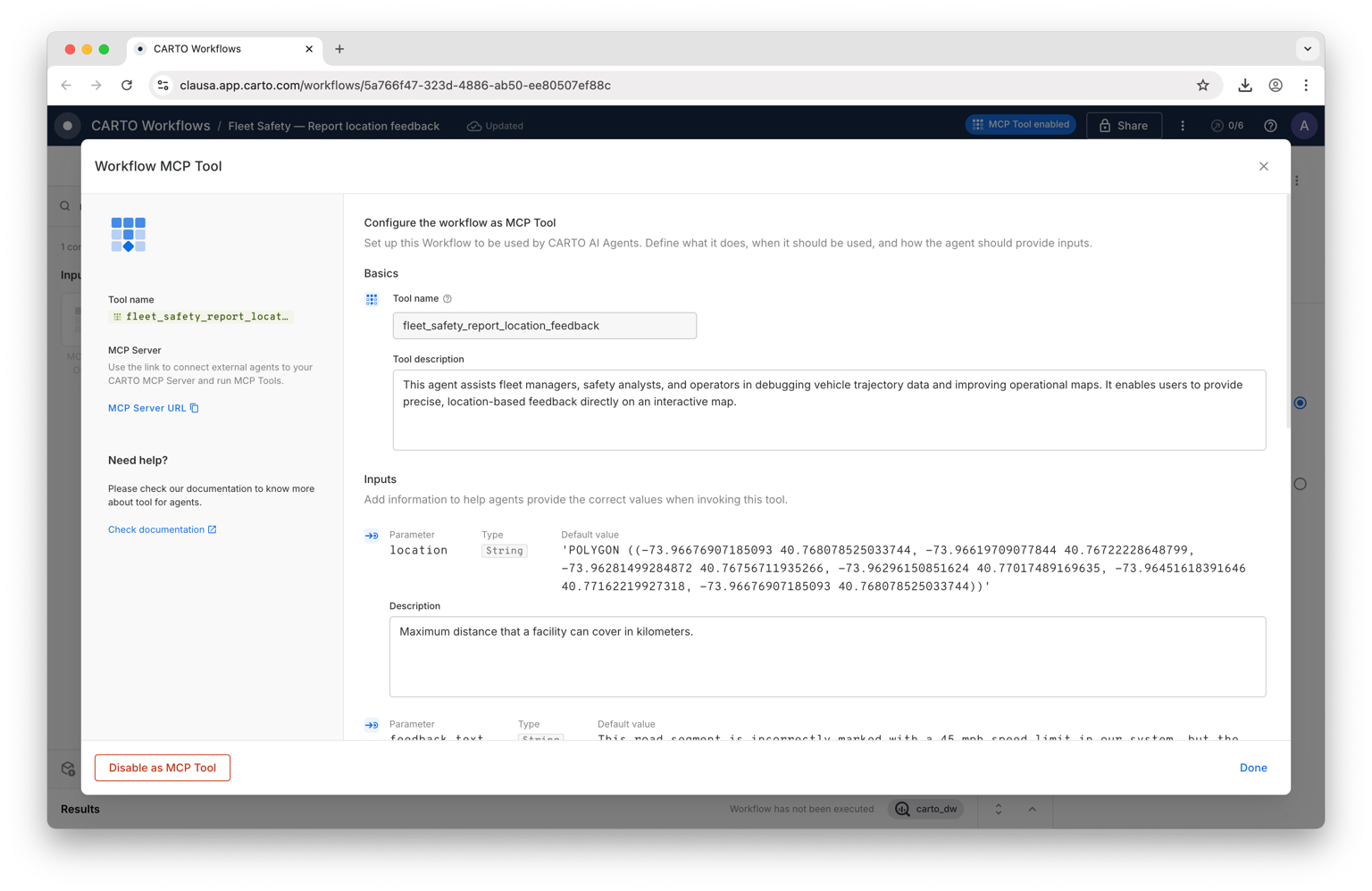
When you expose a workflow as an MCP tool, you provide detailed descriptions for the tool and its parameters. This semantic layer enables AI agents to understand not just how to call a tool, but when to use it and what questions it can answer.
Rather than a generic "spatial analysis" tool, you might create "find_underserved_markets" that "identifies census tracts with high demand but low competitor presence within a specified region".
Let’s see in practice how the CARTO MCP Server democratizes access to geospatial tools for AI Agents:
See how the OpenAI Playground and CARTO MCP Tools work together to perform a geospatial analysis in Chicago. In this demo, an AI agent uses natural language to identify restaurants within a 5-minute drivetime of bank locations, leveraging CARTO’s spatial functions. The agent then creates a CARTO Builder map that visualizes the banks, the drivetime areas, and nearby restaurants—all generated through a single conversational workflow.
Retail planners using Google Gemini Enterprise (as seen in our Site Selection AI Agent) will ask questions like "Which Maryland counties have high income, favorable demographics, and limited competition?" and receive comprehensive site analysis with interactive maps. Executives can now make decisions faster, by transforming days of manual GIS work into minutes of data-driven insights.
CARTO MCP Server can also be used to leverage tools directly in your AI Agents created in CARTO Builder. In the below example, an AI Agent has been configured to run a hotspot analysis workflow when requested by the user to help viewers understand risk from traffic collisions. The map viewer can specify a date range for these hotspots, allowing the tool to be tailored to deliver the specific insights that they need.
Ready to integrate Agentic GIS across your organization with MCP? Here's how to get started:
- Create your first workflow as an MCP tool: start with a simple use case that solves a real problem your team faces regularly. You can follow our guide on enabling Workflows as an MCP tool.
- Connect your own AI Agent to the CARTO MCP server and start experimenting!
- And if you need additional help we’ve prepared documentation and resources:
- Documentation: CARTO MCP Server docs
- Academy course: Agentic GIS with MCP
The Model Context Protocol (MCP) and the new CARTO MCP Server democratize spatial analysis across your enterprise —from data analysts using Gemini or ChatGPT to field teams interacting with custom AI assistants — while maintaining full control over data governance. It's the best of both worlds: enterprise-grade geospatial infrastructure meets accessible, conversational AI.
Ready to bring Agentic GIS to your organization? Start a 14-day free trial of CARTO today, or request a demo to see the CARTO MCP Server in action.