


The Changing Role of the GIS Analyst


.png)
Think about the best GIS Analyst you ever worked with. Don’t you wish you could have ten of them?
GIS Analysts have always been the engine driving Location Intelligence - solving spatial problems, producing maps on demand, and stitching together insights from fragmented data.
Their work is vital, but too often it’s reactive: a queue of tasks rather than a seat at the strategy table. The GIS stack itself hasn’t helped - traditionally siloed, on-premise, and disconnected from the wider data ecosystem. It’s made collaboration hard - and showcasing value even harder.
As a result, GIS teams have often operated on the periphery of organizational decision-making. But that’s changing - fast.
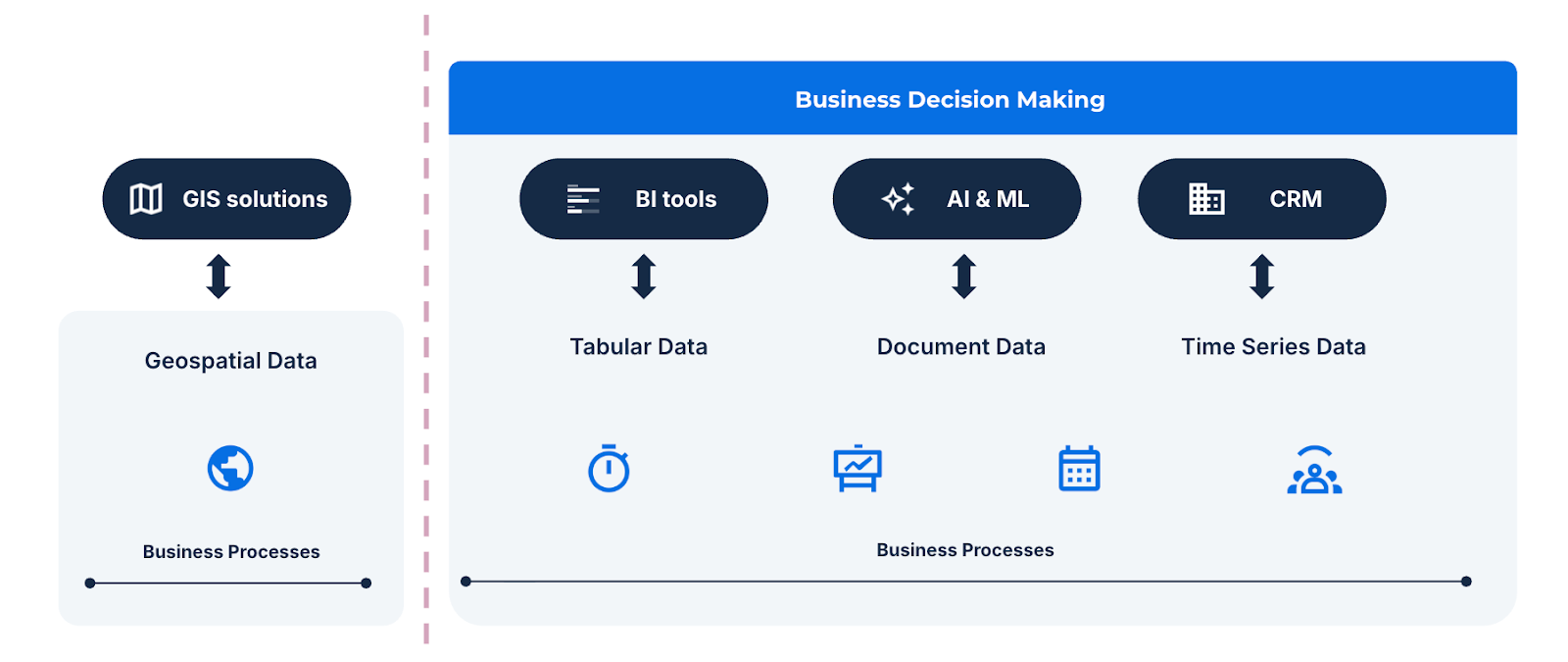
Historically, GIS has lived in its own corner of many organizations. Separate servers, proprietary file formats, steep learning curves, and limited interoperability with core data systems meant spatial data often sat outside the mainstream analytics stack.
As a result, GIS Analysts were often seen as operational rather than strategic - responding to map requests and producing visual outputs that rarely made their way into the systems driving business decisions. Spatial data remained powerful but isolated, its insights locked within specialized tools rather than fueling the analytics engines and AI models shaping enterprise strategy.
Spatial analytics has become one of the fastest-growing areas in enterprise intelligence. The global GIS market reached $9.8 billion in 2023 and is projected to hit $17.8 billion by 2030 - a CAGR of 8.7%. Yet the story for the people driving that growth is very different.
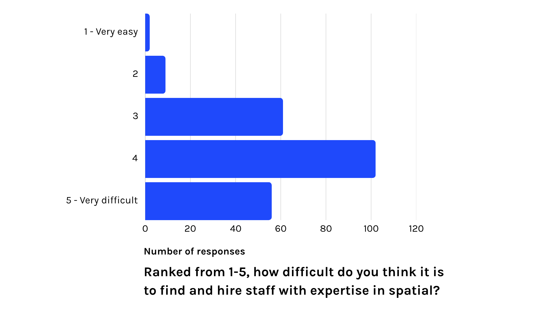
According to the State of Spatial Data Science 2024, nearly 69% of organizations say it’s difficult or very difficult to hire experts in geospatial - a 10-point jump from the previous year. Demand for spatial skills is outpacing supply.
Despite this demand, GIS Analysts earn an average of $66k, in comparison to data analysts who don’t specialize in geospatial - where the average pay is $92k. The gap isn’t just about pay - it reflects how GIS work has been perceived: essential but peripheral.
The result? An industry that’s booming on paper but leaving much of its expert talent under-utilized.
Today, GIS Analysts are being called to play a different role: not just visualizing what’s happening, but designing the systems that help the whole business understand why it’s happening - and what to do next.
Here’s what’s driving that change:
Traditional GIS systems kept analysts and their data on the sidelines. But with the move to the cloud, that separation is finally disappearing.
Cloud-native GIS platforms like CARTO let spatial analytics operate directly within enterprise environments such as Snowflake, Databricks, AWS and Google Cloud’s BigQuery. This is a huge advantage versus legacy GIS systems from which cloud data warehouses can be at best connected to, but not operated inside.
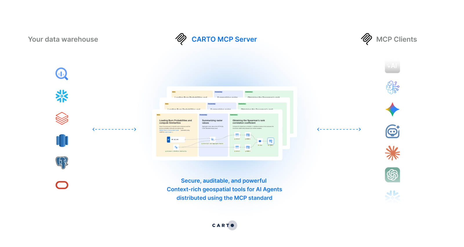
Platforms like CARTO extend this openness even further through capabilities like the CARTO MCP Server, enabling seamless interoperability between spatial reasoning and wider AI ecosystems. Analysts can now expose trusted spatial tools directly within platforms like Google’s Gemini Enterprise, Claude, or custom enterprise AI systems - taking Location Intelligence to wherever users already work.
This represents more than a technical upgrade; it’s a structural change. GIS is evolving from a standalone operation into a connected intelligence layer within the modern data stack. When spatial data flows alongside finance, sales, and logistics data - in a governed, secure, and interoperable environment - GIS analysts move from being reactive specialists to strategic contributors shaping enterprise strategy.
Cloud-native connectivity laid the groundwork - but AI is redefining what it means to be a GIS Analyst.
Through Agentic GIS, analysts are no longer limited to producing static maps or one-off analyses. Instead, they’re becoming builders of agents; geospatial reasoning experiences that operationalize and amplify their spatial expertise across the enterprise. Remember when we asked you to think about the best GIS Analyst you ever worked with? Agentic GIS is how you get ten of that colleague.
By designing AI Agents, GIS professionals can encode their domain expertise - how to interpret, validate, and act on spatial data - into reusable reasoning experiences that anyone in the organization can use through natural language. This marks a fundamental shift in the value they deliver: from answering questions to designing the experiences that can generate answers.
Below: How BT are using Agentic GIS to amplify their geospatial experts - read their story here.
This new model doesn’t replace GIS Analysts - it amplifies them. They become the architects of geospatial intelligence across their organization: defining the logic, data flows and reasoning frameworks that power decision-making. Where they once made maps, they now build agents - scalable, intelligent extensions of their expertise that bring spatial insight to every corner of the organization.
So - what should GIS Analysts be doing to actively take advantage of this shift?
- Build data fluency across the enterprise stack: Understand how spatial data interacts with cloud platforms and AI systems. Integration skills are now as valuable as cartographic ones.
- Think in workflows, not outputs: Start designing agents or automated processes that handle recurring spatial questions. This transforms GIS work from reactive support to strategic enablement.
- Champion responsible AI adoption: As you design spatial AI Agents, ensure governance, transparency, and validation remain at the core - preserving the rigor that defines GIS excellence.
With these steps, GIS Analysts can redefine their impact - moving from being request responders to becoming builders of intelligence infrastructure.
The role of the GIS Analyst is changing - and that’s something to be excited about!
The combination of cloud-native data and agentic automation means spatial expertise can finally scale across the enterprise. GIS professionals who embrace this shift will be at the center of how organizations see, reason, and act.
CARTO’s Agentic GIS gives you the tools to start that journey - securely, governably, and without compromise. Start your free 14-day trial here and build your first agent today!


.png)
.png)