


Unlock planetary-scale insights with CARTO & Google Earth AI


.png)
Every minute, our planet generates terabytes of new data - whether that’s from satellites, sensors, or the mobile device you’re probably reading this article on now. This data covers everything from weather patterns to land use to human movement… sounds fantastic, right? But making this data actionable and meaningful is a real challenge.
Enter Google Earth AI.
Developed by Google Research, Earth AI combines state-of-the-art foundation models for imagery, population, and environmental systems with Gemini-powered reasoning agents to answer complex, real-world questions at planetary scale.
In this article, you’ll learn how Google and CARTO are bringing planetary-scale intelligence to organizations everywhere - combining Google Earth AI with CARTO’s Agentic GIS platform to power smarter decisions across site selection, risk analysis, marketing, and supply chain planning.
At the core of Earth AI is Geospatial Foundation Models (GFMs) - powerful embeddings and predictive models that capture patterns across population, environmental, and imagery data. These include:
- Remote Sensing Foundations: extract insights from satellite imagery with vision-language and object detection capabilities
- Environment Foundations: model weather, flooding, and other environmental phenomena.
- AlphaEarth Foundations: assess risk using geospatial embeddings and vector similarity search, helping improve operational planning and resilience.
And many more! Google Earth AI unifies these outputs in a Geospatial Reasoning Agent that orchestrates queries and fuses insights across domains. These insights enable organizations to answer complex questions - such as forecasting flood risks, identifying vulnerable populations, or finding optimal locations for new sites - without manually combining dozens of datasets or building custom models from scratch.
CARTO aims to make Foundation Models more accessible to organizations through our cloud-native platform, where users can:
- Leverage pre-trained embeddings without building models from scratch
- Use low-code workflows and AI Agents to interact with Foundation Models
- Maintain enterprise-grade governance while building decision-making pipelines
This integration removes barriers to advanced spatial analytics, turning planetary-scale intelligence into actionable decisions - all without specialized AI or GIS expertise.
One of the most exciting foundation models is Google’s Population Dynamics Foundation Model (PDFM). The PDFM captures monthly embeddings across 17 countries - representing population, mobility, and socioeconomic behavior. These embeddings have been shown to significantly improve forecasting accuracy in real-world applications, from public health to disaster response.
The PDFM is part of Google’s Earth AI suite of models that also includes Imagery and Environment Foundations, allowing insights to be fused across domains.
By combining these models, Earth AI can produce richer, more accurate predictions - for example, improving FEMA’s U.S. National Risk Index by an average of 11% for certain hazards when socioeconomic and environmental embeddings are used together.
Let’s explore an example of this in action!
In geomarketing, expanding a successful pilot campaign to new markets often means finding areas with similar audience profiles - a process that can take weeks of manual segmentation and data blending.
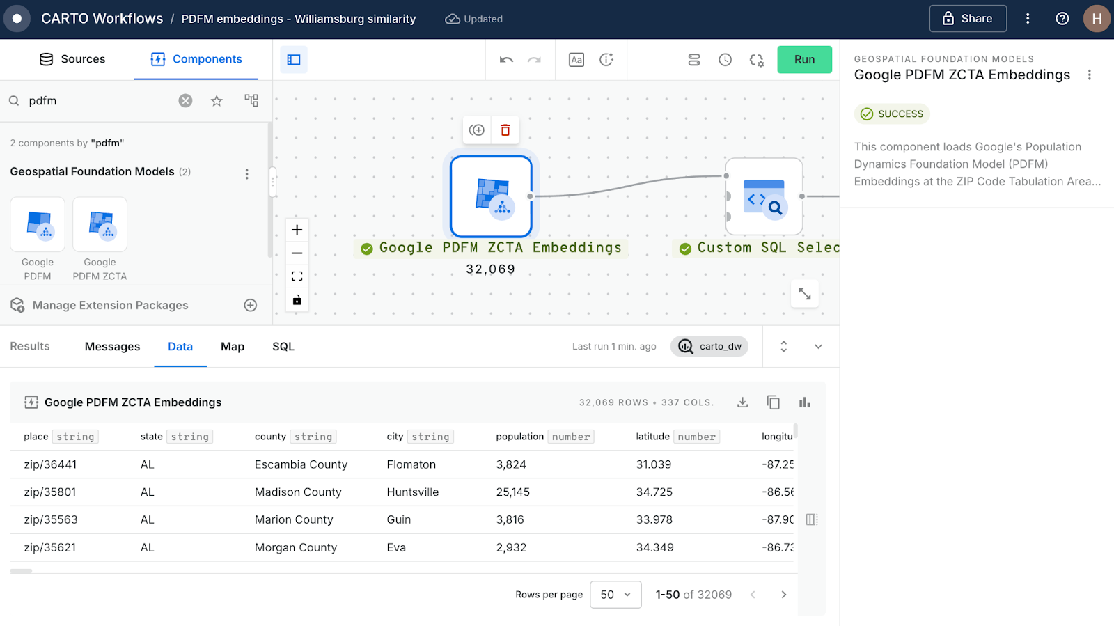
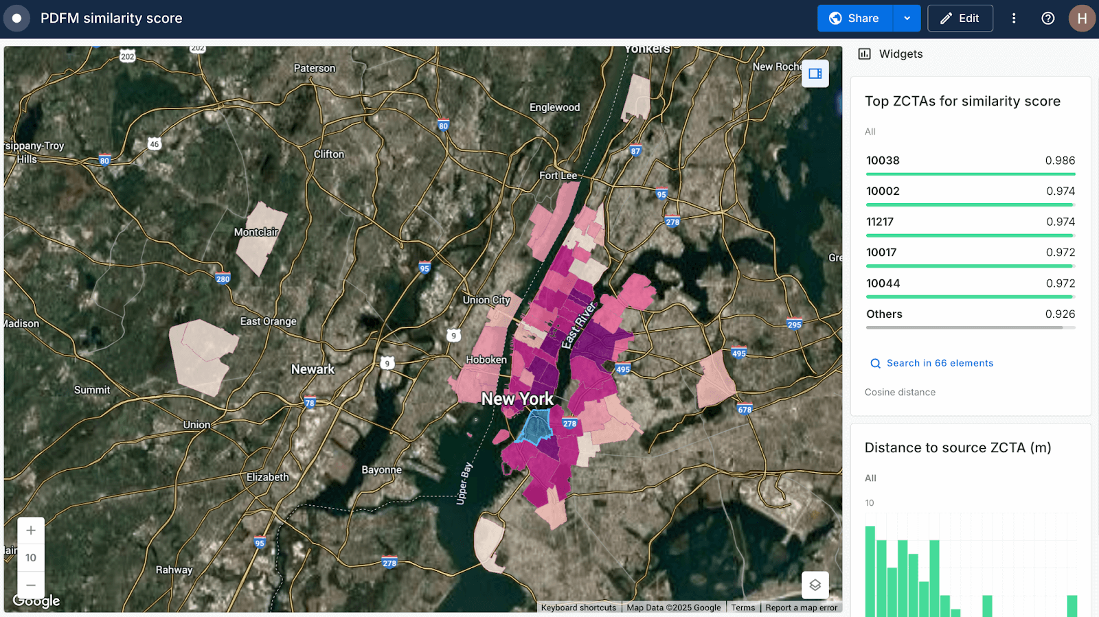
Using PDFM embeddings in CARTO Workflows (see above), we identified a high-performing ZIP Code (11201, Williamsburg, NYC) and calculated the cosine similarity (a measure of how closely areas resemble each other) of every other ZIP Code. The result: a list of the 100 top ‘lookalike’ areas to replicate campaign success.
You can explore the results of this analysis in the CARTO Builder map below (or open in full screen here).
This analysis becomes even more accessible when utilizing a more agentic approach with CARTO. Rather than just viewing a static map of the most similar ZIP Codes, users can interact directly with an AI Agent, by asking questions like, “I’m looking for the 5 top ZCTAs to roll the campaign out to which have a population of at least 25,000” (see below). The AI Agent filters, ranks, and highlights the optimal areas based on these criteria - allowing stakeholders to explore tailored options without requiring the analyst to anticipate every exact requirement.

See more examples of the PDFM in action in our recent webinar "Building More Accurate Spatial Models with Google PDFM Embeddings and CARTO."
Beyond geomarketing, the integration of Google Earth AI and CARTO enables organizations to apply geospatial intelligence across a wide range of critical business and operational challenges, including:
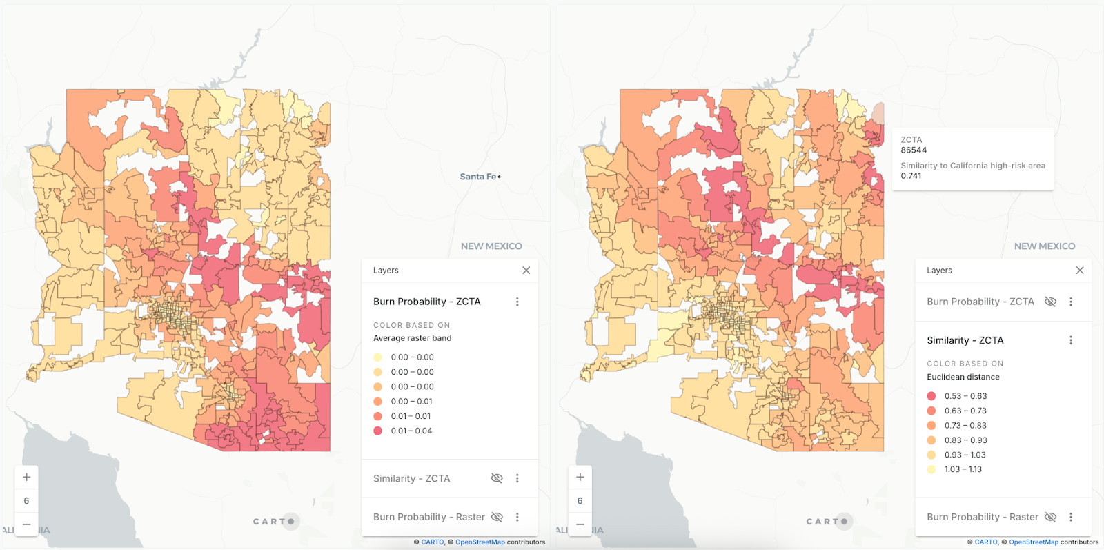
- Risk Analysis: Detect and forecast environmental or socio-economic risks, from flooding to population vulnerability. Check out this example of Google DeepMind’s AlphaEarth Foundations being used to detect fire-prone regions using vector similarity search - and learn more in our upcoming webinar with Google!
- Territory Planning: Balance sales or service territories intelligently using multidimensional spatial features.
- Supply Chain Optimization: Anticipate disruptions, plan resilient logistics, and allocate resources efficiently.
- Site Selection: Identify optimal locations for stores, facilities, or service points using population and mobility embeddings. You can see this in action below with our new CARTO Site Selection AI Agent for Gemini Enterprise!
By embedding planetary-scale models into workflows, organizations can move from data discovery to actionable insight in minutes - not months. Because these capabilities are grounded in the same foundation models and reasoning agents that power Google’s own planetary-scale systems, they’re not just accurate - they’re explainable, transparent, and accessible to everyone.
Google Earth AI continues to advance with more frequent updates to foundation models, expanded coverage, and tighter integration with the Geospatial Reasoning Agent - making planetary-scale analysis faster and more accurate.
On the CARTO side, upcoming embedding-based analytics will make obtaining insights from foundation models even more accessible with the following new tools:
- Similarity Search: Quickly find similar neighborhoods, parcels, or regions for recommendations and anomaly detection.
- Clustering: Identify patterns and clusters across demographics, land use, and environmental features.
- Visualization: Map embeddings to reveal trends, clusters, and outliers intuitively.
- Change Detection: Track urban growth, wildfires, crop cycles, and population shifts over time.
- ML with Embeddings: Use embeddings as features for predictive models, reducing manual feature engineering.
These advancements will make planetary-scale intelligence more interactive, accessible, and actionable - helping teams turn complex geospatial data into insights faster. Make sure you sign up to our newsletter the Spatial Dispatch to get these updates delivered straight to your inbox!
With Google Earth AI and CARTO’s Agentic GIS, teams can turn complex geospatial data into actionable insights in minutes - enabling faster, smarter decisions at scale.
Ready to see it in action? Request a demo or start a free trial to unlock the power of planetary intelligence for your organization.


.png)
.png)