What’s new in CARTO - Q4 2025


.jpg)
As 2025 has come to a close, it’s clear this has been a transformational year for CARTO, and for the geospatial industry as a whole. We’ve crossed a threshold where AI applied to GIS is no longer a promise but a reality. Agentic GIS represents that shift: a new way of working where humans set the intent and AI agents take on the heavy lifting of spatial exploration, analysis, and iteration. This year marks a turning point for the GIS industry, as AI shifted from experimentation to trusted decision-making, with geospatial AI Agents at the center of that change.
This last quarter, we turned our AI vision into reality. We launched enterprise-grade Agentic GIS capabilities across our platform to fundamentally change how people interact with spatial data. This approach brings together geospatial foundation models for spatial reasoning and pattern detection at scale, embedded AI Assistants that streamline repetitive tasks, and AI Agents that automate geospatial workflows, deliver instant insights, and put Location Intelligence in the hands of everyone across your organization. CARTO’s Agentic GIS approach is designed to operate entirely within your governed cloud environment: your data never leaves your data warehouse, and you can safely leverage your own vetted AI models and endpoints while ensuring full compliance and security.
Now let’s take a look at more highlights from last quarter’s CARTO release - and remember to keep an eye on our What’s New page for the latest updates.
Helps you to : Build trustworthy AI agents and tools that make complex geospatial analysis accessible to any user within your organization.
De-risk spatial insights from getting siloed away in your organization. With CARTO AI Agents, you can provide a conversational interface in your maps where end users can get instant and actionable geospatial insights. Agents can now reason and perform geospatial analysis autonomously, from querying sources to generating layers and leveraging geospatial workflows as tools. By configuring your own AI models from providers like Google Gemini and OpenAI (and more coming soon), you can create and share powerful geospatial AI Agents tailored to your specific needs.
Learn more about this revolutionary step forward in our announcement blog post and in our documentation.
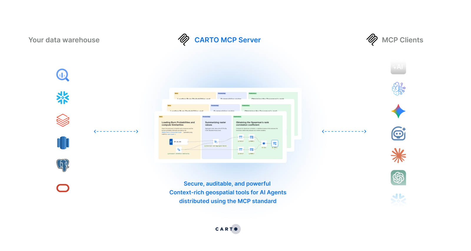
Helps you to: Empower AI Agents with MCP Tools to perform advanced spatial analysis and inform geospatial reasoning.
Your agentic tools should be interoperable and accessible. CARTO now supports Model Context Protocol (MCP), allowing teams to design workflows as MCP Tools exposed through the CARTO MCP Server. These tools are powered by CARTO Workflows which define how spatial problems are solved. The results are then passed to an AI Agent of choice for geospatial reasoning in your CARTO maps. This multiplies the power of GIS teams by enabling scale, automation, and dissemination of insights, making spatial analysis accessible to everyone. Learn how to leverage MCP Tools in our documentation.
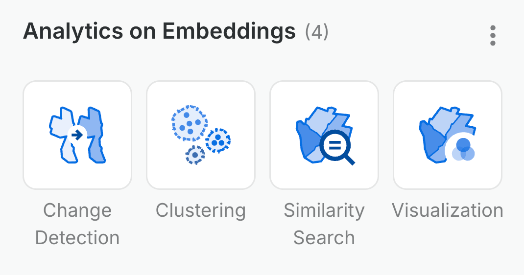
Helps you to: Analyze and visualize foundation model embeddings in workflows for AI-driven spatial insights.
Performing analytics on Foundation Models (FMs) takes time and expertise. CARTO now democratizes spatial insights with the Analytics on Embeddings Workflows extension package, a new set of components that bring high-dimensional embedding analytics to your pipelines. This unlocks greater access and insights to spot changes in human attitudes on social media, population changes, or even weather patterns without leaving the low-code CARTO Workflows environment. Learn more in our documentation.
Helps you to: Experiment freely, track your map's evolution, and restore previous versions with a single click.
Analytics teams can more easily track, collaborate, and manage map versions as business and stakeholder needs change without having to start over. CARTO Builder now has Version history where you can mark important milestones and restore older drafts to experiment and iterate without fear. This works seamlessly tracking every change with the collaborator's name and timestamp, so you have a complete audit trail. Learn how to leverage version history for your team in our documentation.
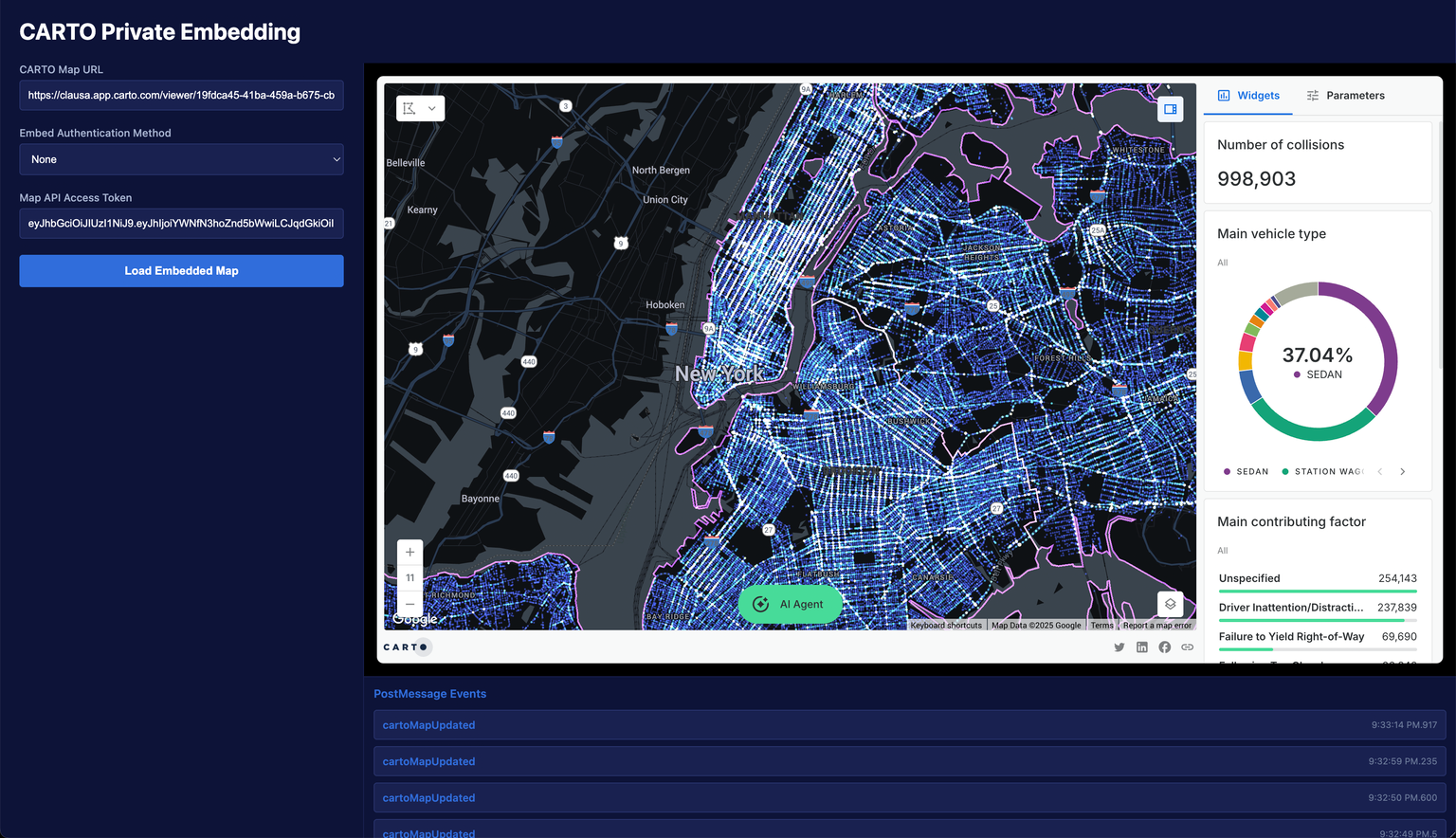
Helps you to: Create powerful, seamless interactive experiences when embedding your private maps in other webpages and applications.
Embedding private maps became exponentially easier and more powerful. CARTO now has added new strategies to embed private maps securely without forcing users to log in separately. Embedded maps now send postMessage events when the map state changes, allowing you to craft truly interactive experiences in your BI tools and web apps. Learn how to embed your next CARTO map in our documentation.
Helps you to: Run CARTO alongside your existing Oracle GIS infrastructure and maintain continuity with your established systems and workflows in Oracle.
Oracle has been the foundation for mission-critical spatial workloads for decades. No need to leave that behind! Moving from desktop-bound workflows to cloud-native scalable analytics in Oracle is now possible. Unlock the future for geospatial AI with AI Agents and the cloud-native integration with Oracle Autonomous AI Database. Learn more about support for Oracle on this page.
Helps you to: Find and access your most-used data assets instantly.
No more browsing the data tree until you find what you need! You can now star items at any level in the Data Explorer - from connections to individual tables. Simply click the star icon and use the starred only filter to see your favorites. Your starred items are also easily accessible when adding a data source in CARTO Builder and CARTO Workflows, streamlining your map and workflow creation process. Learn more in our documentation.
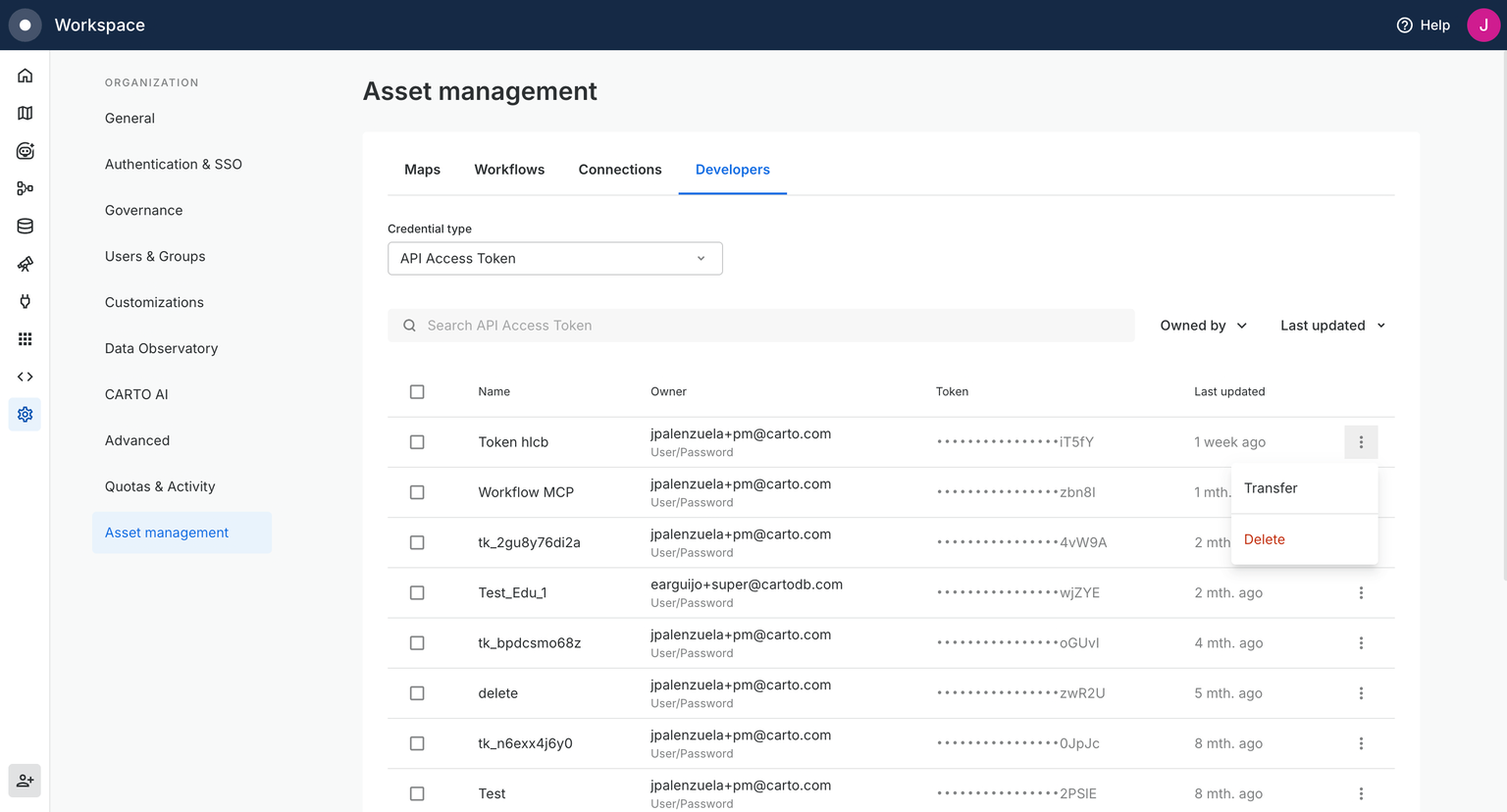
Helps you to: Ensure business continuity and streamline developer collaboration without disruption.
Avoid access and security challenges while a team member is out on holiday! Superadmins can now have the ability to view and manage all developer credentials (API Access Tokens, SPA & M2M OAuth Clients) from a single Asset Management table. This allows Superadmins to find, transfer, and delete credentials seamlessly, preventing disruptions by building in redundancies and peace of mind for your organization to keep running smoothly. Learn more in our documentation.
—
That’s a wrap for the end of 2025 updates!
From putting conversational AI in your hands to enhancing your day-to-day integrations and analytics, these features are designed to make your spatial analysis even more powerful and resilient.
To keep up with the latest releases, visit the What’s New page of our Documentation and follow us on LinkedIn for live updates, or sign up for our newsletter to get highlights straight to your inbox.
Want to sharpen your skills? Explore hands-on tutorials in CARTO Academy. Not a CARTO user yet? Start a 14-day free trial and experience these new features yourself!