


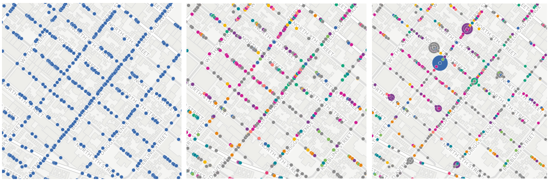
Turning Geospatial Foundation Models into Decisions using CARTO Workflows
CARTO now lets you run analytics directly on geospatial foundation model embeddings. Visualize, cluster, and detect changes to turn spatial data into decisions.


CARTO’s Open Data Week 2016 Preview
Immerse yourself in the world of Open Data at CARTO's Madrid event! Engage with global innovators, explore workshops, and join discussions.

Geospatial Learning Across the Curriculum at NYU
NYU collaborates with CARTO to enhance GIS learning, enabling students to utilize location intelligence across disciplines.


Boom or Bust! What Enigma’s newest project tells us about the economy of North Dakota
Explore Enigma's Boom or Bust project, delving into North Dakota's economy using CARTO for compelling visual storytelling.

Creating Category Maps with CARTO Builder
Learn to create Data-Driven Maps with CARTO Builder! Color-code geospatial features by category effortlessly. Improve decision-making now!

CartoDB to CARTO: the Back Story to our New Brand
Discover the rebranding of CartoDB into CARTO, a cloud-native platform enhancing location intelligence and spatial data analysis capabilities.
Connect and learn with CARTO in September
Explore groundbreaking spatial analysis & visualization innovations by CARTO. Join us at events worldwide & dive into data insights. Discover more!


Excited for SXSW 2017? Vote for our CARTO-inspired submissions for Interactive!
CARTO at SXSW 2017! Explore geospatial innovation with our panels - Eye in the Sky, Multi-Dimensional Mapping, Open Geo in the Age of Pokémon Go.

Academy
Turning Geospatial Foundation Models into Decisions using CARTO Workflows
CARTO now lets you run analytics directly on geospatial foundation model embeddings. Visualize, cluster, and detect changes to turn spatial data into decisions.

The State of Spatial Analytics 2026 - Register interest!
Key findings from the survey reveal major changes since 2024. Register interest now and get early access to the State of Spatial Analytics 2026 Report.


What is Agentic GIS?
Discover Agentic GIS: AI-powered spatial analysis that automates workflows, amplifies GIS expertise, and delivers actionable geospatial insights.

.png)